| Related resources : |
Cartography - GIS - Teledetection
|
 | Geographic Information Systems (GIS) Poster (article) |
 | Fayoum & Al Minya basins (map) |
| Definition of ICA Network - Júcar water quality control network (map) |
| Territories linked to the Durance river - Provence Alpes Côte d'Azur (PACA) - France (map) |
| The Piave River Basin (Italy) (map) |
| Lower Genil basin - Cacin canal irrigated lands (map) |
| Júcar / Xúquer river USUJ water users associations (map) |
| Lebanon Hydrological Network (map) |
| Nile river basin (map) |
| Intake of El Resqa Canal and irrigation system - Behera, Egypt (map) |
| Morocco- Haouz irrigated areas (map) |
| Irrigation canals of Pyrénées - Orientales 1874 (map) |
| Irrigation mountain systems in the Têt basin valley (map) |
| Map of the lower valley of Têt river - regions' main irrigation systems in 1973 (map) |
| The regions of the Hydrographic Confederation of the Júcar (map) |
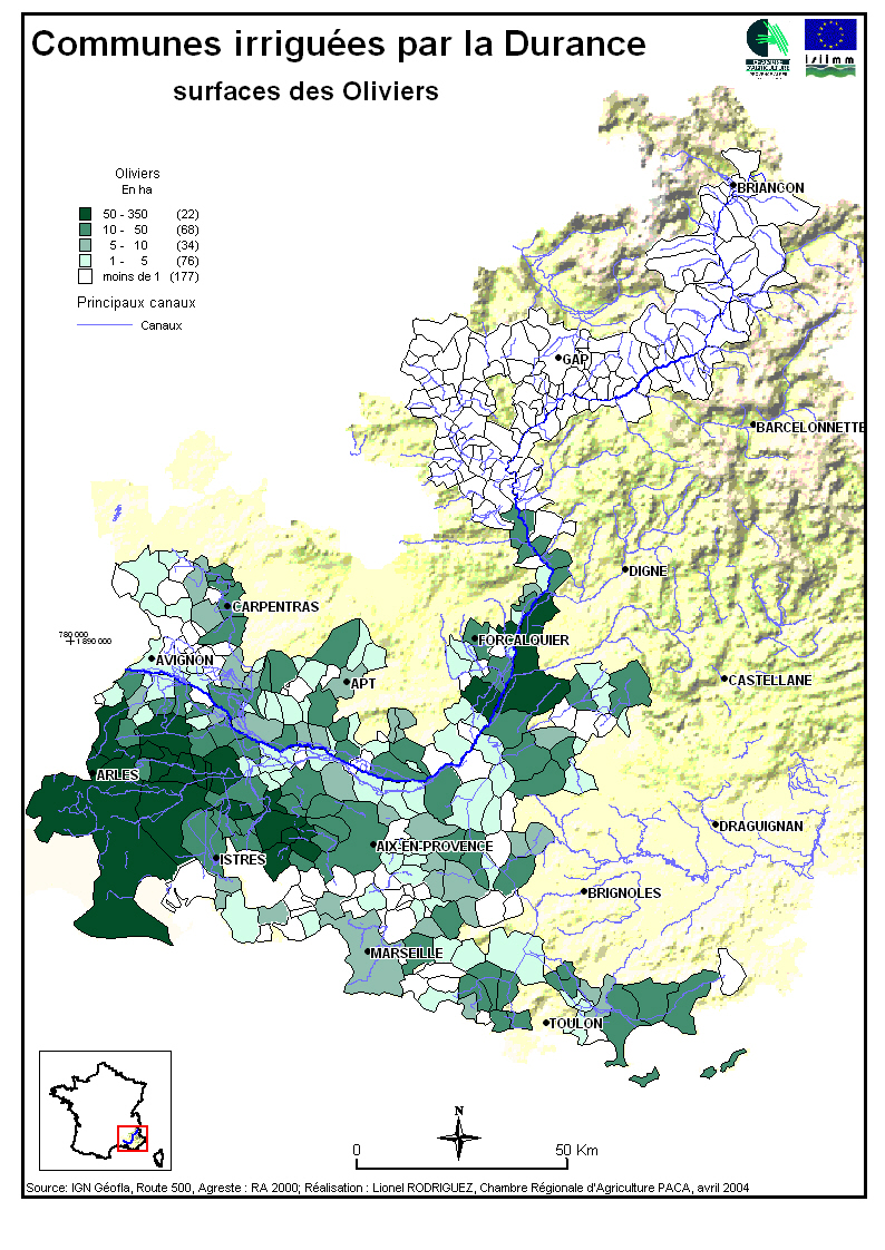
| Communities irrigated by the Durance - irrigated surface (map) |
| Hydraulic Networks in the PACA area (map) |
| Piave hydrographic network map (map) |
| Egypt - Minya : Situation map of ISIIMM Study Zone (map) |
| Egypt Minya - Study zone Irrigation system (map) |
| Consortium Destra Piave map (map) |
| Biogeographiques areas of Piave basin - Italy (map) |
| Hidrografic map of Piave basin (map) |
| Irrigation perimeters map of the Piave study zone (map) |
| CorineLandcover - Soil use map in the study zone of Piave - Italy (map) |
| Seila - ISIIMM study zone perimeter in Fayoum, Egypt (map) |
| Corine Landcover 2000 classes legend (map) |
| Morocco - Haouz Office Perimeter (map) |
| Situation map of Ait Bouguemez valley (map) |
| Morocco - Hydraulic organisation of Ait Hakim valley - Ait Bouguemez (map) |
| Water supply of Beirut and new territory division - Lebanon (map) |
| Territorial limits of water management, limits of the States and the regions - France, Spain and Italy (map) |
| World:Map of Tahnasha - Muhafazat al Minya, Egypt (map) |
| Global Gazetteer Version 2.1 - maps and many more (map) |
| Map of Veneto region, Italy (map) |
| Map of the Bekaa - Lebanon (map) |
| Mantout command area - Minya, Egypt (map) |
| Egypt Minya 1972 (map) |
| Seila area ISIIMM study zone, Fayoum, Egypt (map) |
| Communes irrigated by the Durance: industrial agriculture and cereals surfaces areas (map) |
| Communes irrigated by the Durance: forage surface areas (map) |
| Communes irrigated by the Durance: vegetables surface areas (map) |
| Communes irrigated by the Durance: olive surface areas (map) |
| Communes irrigated by the Durance: vegetable surface areas in the SAU (Useful Agricultural Zones) (map) |
| Communes irrigated by the Durance: percentage of irrigated areas in the irrigable area (map) |
| Communes irrigated by the Durance: surface areas for producing grapes for direct consumption (map) |
| Communes irrigated by the Durance: grass surface areas (map) |
| Communes irrigated by the Durance: average surface of farms (map) |
| Communes irrigated by the Durance: orchard surface areas six species (map) |
| Communes irrigated by the Durance: vignard surface area (map) |
 | Cartographic repertory France 1999 - 4th edition (report) |
 | NASA Landsat 1990/2000 geocover satellite images (satellite_image) |
| An Introductory Landsat Tutorial (satellite_image) |
| Lebanon : The five villages irrigated by the canal 900 - Litani (satellite_image) |
| Egypt worksites ISIIMM - Behera, Fayoum, Menia (satellite_image) |
| Egypts ISIIMM worksites situation map : Behera (El Resqa, Newlands), Fayoum (Seila), Menia (satellite_image) |
 | RNDE - National Water Data Network - France (resource) |
| Perry-Castañeda Library Map Collection (resource) |
| Languedoc-Roussillon region soil database - France (resource) |
| EEA Maps and graphs - Corine Landcover 2000 by country (resource) |
 | Chaine of bassins in the Nile valley in the XIXth century (schema) |
| Morocco - Hydraulic organisation schema of Ait Hakim valley - Ait Bouguemez (schema) |
| Manosque canal, France - Network organisation schema (schema) |
 | MrSID - multiformat image viewer (software) |
| Tutorial Canvas 6 & 7 (software) |
| Free GIS software - fGIS (software) |
| Google Earth (software) |
 | David Rumsay Historical Map Collection (link) |
 | Guidelines for Canvas 6 : synthesize the territory (guidelines) |
| Schématiser le Territoire - Schematising Territory (guidelines) |
| Guidelines Canvas 6 : mapping the territory (guidelines) |
 | Extraction of old maps from XVII to XIX century (doc) |
| Maps: situation of Durance (doc) |

 photos